Sizing information
| Overall size (inc frame) | x cm ( x in) |
| Depth | cm (in) |
| Artwork | x cm ( x in) |
| Border (mount) |
cm
top/bottom
(in)
cm left/right (in) |
| The paper size of our wall art shipped from the US is sized to the nearest inch. | |

Our prints
We use a 200gsm fine art paper and premium branded inks to create the perfect reproduction.
Our expertise and use of high-quality materials means that our print colours are independently verified to last between 100 and 200 years.
Read more about our fine art prints.
Manufactured in the UK, the US and the EU
All products are created to order in our print factories around the globe, and we are the trusted printing partner of many high profile and respected art galleries and museums.
We are proud to have produced over 1 million prints for hundreds of thousands of customers.
Delivery & returns
We print everything to order so delivery times may vary but all unframed prints are despatched within 1–3 days.
Delivery to the UK, Ireland, mainland EU & US is free when you spend £75. Otherwise, delivery to the UK costs £5 for an unframed print of any size.
We will happily replace your order if everything isn’t 100% perfect.
Product images of Map of Antietam, Sharpsburg and Vicinity, Maryland


Product details Map of Antietam, Sharpsburg and Vicinity, Maryland
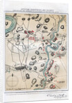
Map of Antietam, Sharpsburg and Vicinity, Maryland
Map of Antietam, Sharpsburg and Vicinity, Maryland, 1862 (1862-1867) The Battle of Antietam, fought on 17 September 1862, was the first battle of the American Civil War to be fought on Union (northern) soil. It was the bloodiest single day battle in American history, with nearly 23,000 casualties. An engraving from volume II of The War with the South : a History of the Late Rebellion, by Robert Tomes, Benjamin G Smith, New York, Virtue & Yorston, 3 Volumes, 1862-1867.
- Image ref: 1272958
- The Print Collector / Heritage-Images
Find related images
zoom